
I'm a map nerd, as Clever Wife would be the first to point out, but even if you are not a map nerd, this is just too cool for words.
LAWRENCE of Arabia's vision for the Middle East has been revealed in a map he created after World War I.
T.E.Lawrence, the British colonel whose wartime collaboration with the Arabs against the Turks was immortalised in the 1962 film Lawrence of Arabia, attempted to reward Britain's Arab allies by dividing territory between them.
His sympathy for the cause of Arab self-determination is well known, but the details contained in the map eluded historians because it was filed at Britain's archives under the wrong date.
The missing map has been found and is one of the highlights of a new Lawrence show at the Imperial War Museum in London.
The fate of the Middle East was largely decided by a high level agreement between the British and French foreign ministries with no participation from the local populations. The Turks, who had previously ruled most of Arabia, were limited to ethnically Turkish areas of Anatolia (the western part of the current Turkish Republic). The French were given control over Lebanon and Syria with access to the Tigris River and to Southeastern Turkey. The British were given control over Iraq, Palestine, and Jordan. The Armenians were to be given a state in Northeastern Turkey. Arab self-rule was limited to the least economically useful parts of the region. The area that is now Iraqi Kurdistan was disputed between the British and French, but later given to the British after some adjustments were made between Jordan and Syria to favor the French. This plan has been a disaster that we have had to live with for the last eighty years.
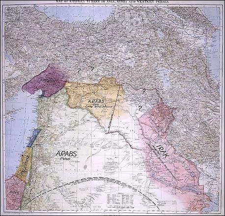
Till now we have known that Lawrence's plan included Arab self-rule over a much larger area and a much smaller role for the British and French, but we have not known the details of his borders. The newly discovered map shows most of the Northern Arab lands including Jordan, Syria up to the Euphrates, and the Muslim parts of Lebanon united under Prince Feisal, the son of Sherif Hussein of Mecca (who was expected to rule most of the Arabian peninsula). The French would have controlled Beirut and most of the Christian areas in the Lebanon Mountains. The British would have controlled The southern two-thirds of Iraq (it's interesting to note that the map shows this state united with Kuwait, a region that the British already controlled). He shows Palestine as a separate state but doesn't indicate who would be in control (at the time the leading contender was that it would be an international zone, open to all religions).
The most interesting elements of Lawrence's plan is that he shows a northern state, to be awarded to Zaid, the youngest son of Sherif Hussein, that includes much of the Kurdish territory that now divided between Iraq, Syria, and Turkey. He also shows a small Armenian state on the Mediterranean, straddling the current Syrian-Turkish border. At the time, this area was called Little Armenia by some and still had a significant Armenian population.
Lawrence's plan has it's own weaknesses--his smaller Iraq would still have been a difficult state to hold together and he leaves Palestine up in the air--but, in many ways it is a vast improvement over what the peace conference created. Then as now, Politics was usually decided by the powerful while the experts and the people affected merely got to watch from the sidelines. As it was in Iraq in 1919, so it will be in Iraq and New Orleans in 2005.


No comments:
Post a Comment